Original County Records · Authority Chain
The Record
The County's own maps and adopted plans establish what the land use designation was when SOAR was adopted. The materials reviewed to date do not identify the adopted authority reconciling that designation with the ECU-Agricultural / Existing Community approval pathway relied on for Ventura Ranch.
THE AUTHORITY CHAIN
Adopted 1984 · Confirmed in Record
NVAA — Open Space / Agricultural Designation
? Missing Adopted Act
Not identified in materials reviewed to date
County's Present Framework
ECU-Agricultural / Existing Community
County Approval — PL23-0051
Ventura Ranch — 328-Unit Approval
The record shows the beginning and the end. The materials reviewed to date do not identify the adopted act in the middle.
Original County Records
The SOAR-Baseline Record Places the Parcel Outside the Existing Community Boundary
The County's own General Plan Land Use Map — the map that existed when SOAR was adopted — shows the parcels at 4884 North Ventura Avenue within the Agricultural/Open Space planning framework, not within the Existing Community Urban area. The North Ventura Avenue Area Plan designated the 71-acre corridor for continued County Open Space and City Agriculture use, preserved from urbanization. Today the County relies on a modern ECU-Agricultural designation as the approval pathway. The adopted record at SOAR adoption has not been identified as showing that designation for these parcels.
The record shows the beginning and the end of that story. The bridge has not been identified in the materials reviewed to date.
The Maps — County's Own Records

GP Land Use Map — Sept. 16, 1997 (South Half)
The governing map at SOAR adoption. County Planning staff confirmed in writing this is the map SOAR attached to. Parcels at 4884 N. Ventura Ave. are outside the ECU dashed boundary — in agricultural designation.
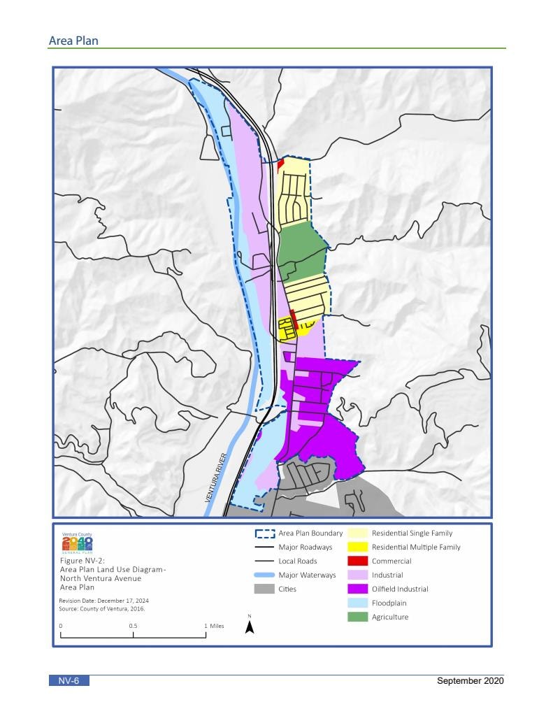
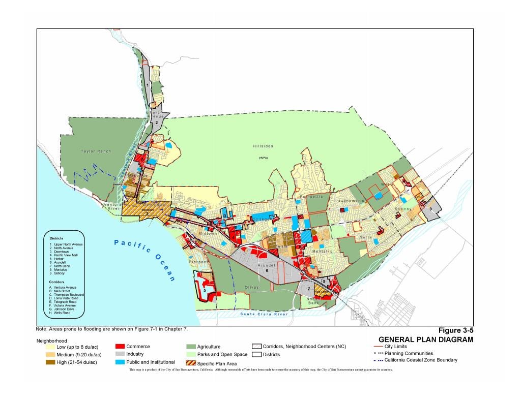
NVAA 2040 Land Use Diagram & City General Plan — Parcels in Agricultural Area
The NVAA 2040 Figure NV-2 and the City of San Buenaventura General Plan Diagram both show the parcels at 4884 N. Ventura Ave. designated Agricultural.
County Planning Department — Public Records Response
In response to a Public Records Act request, County Planning Department staff confirmed in writing that the General Plan Land Use Map adopted September 16, 1997 — South Half — is the governing map at the time SOAR was adopted.
On that map, the parcels at 4884 N. Ventura Ave. and the area behind Bounds Road are outside the ECU dashed boundary — in agricultural designation. The County identified the governing document. That document has not been identified as showing these parcels as ECU-Agriculture. The materials reviewed to date do not identify an adopted authority placing them inside the ECU boundary.
North Ventura Avenue Area Plan
The NVAA Formally Designated This Land
The North Ventura Avenue Area Plan performed an explicit screening exercise before designation. Lands not meeting the criteria for Existing Community or Phased Urban were formally placed in Open Space / Agricultural. The 71-acre corridor north of Bard Lane / east of Ventura Avenue was among them.
That designation appears in the County's own adopted record. The materials reviewed to date do not identify the adopted act reconciling that designation with the current approval framework.
The NVAA formally designated this land Open Space / Agricultural after an explicit screening exercise. The materials reviewed to date do not identify the adopted act reconciling that designation with the current approval framework.
THE RECORD AT A GLANCE
Record Shows
Record Does Not Yet Show
NVAA designation — Open Space / Agricultural (1984)
Bridge act: adopted authority moving land from Agriculture/Open Space to Existing Community before SOAR
SOAR baseline map — Agriculture / Open Space, outside ECU boundary (September 16, 1997)
ECU transition authority: what adopted act, if any, changed the designation between 1997 and GP2040
GP2040 ECU-Agricultural designation (current)
Applying determination: Board findings establishing preexisting lawful urban uses and minimum-extent boundary required by Measure C EC exception
KEY DOCUMENTS
Ten Documents That Define the Question
These are the ten documents most central to the authority-chain question. Each one either establishes what the record shows or identifies what is missing from it.
North Ventura Avenue Area Plan (1984)
The adopted County planning document that formally designated the Bounds Road / Bard Lane corridor for continued Open Space and Agricultural use after an explicit agricultural screening exercise. This is the baseline designation before SOAR.
General Plan Land Use Map — September 16, 1997
The map SOAR attached to at adoption. Shows the parcels at 4884 N. Ventura Avenue in Agriculture / Open Space designation, outside the Existing Community Urban boundary. This is the SOAR baseline.
SOAR — Measure B (1998)
The voter initiative that requires voter approval for most General Plan changes involving Agricultural, Open Space, and Rural land. Attaches to and protects the September 16, 1997 maps.
SOAR — Measure C (October 2015)
Amends, reaffirms, restates, and readopts SOAR. Protects Ag/OS/Rural lands on maps revised through October 20, 2015. The Existing Community exception requires preexisting lawful urban uses and Board findings.
GP2040 General Plan Land Use Map — ECU-Agricultural Designation
The County's current General Plan designates the site ECU-Agricultural. This is the designation the County relies on for the approval pathway. The adopted authority establishing this designation has not been identified in materials reviewed to date.
Resolution 20-106 — Board of Supervisors
A Board resolution identified in the authority matrix as part of the identified record. Its relationship to the ECU-Agricultural designation and the SOAR framework is part of the authority-chain question.
County Staff Report — PL23-0051
States: 'The project site is designated ECU-Agricultural on the County General Plan Land Use Map.' Does not identify the adopted authority establishing that designation.
Petition for Writ of Mandate — Case No. 2026CUWM063387 (April 2, 2026)
The writ petition asking the Court to determine whether the County identified the adopted authority required to approve the project under SOAR, the NVAA, the ECU-Agricultural designation, and the General Plan.
Minute Order — October 14, 2026 (Court Ruling)
The Court denied the motion for leave to file a First Supplemental and Amended Petition. The Court expressly stated that its ruling addressed the amendment request and did not adjudicate the ultimate viability of the original April 2, 2026 petition. The original petition remains the operative pleading. This ruling is now part of the case record.
County PRA Response — October 23, 2026 Deadline
The County's response to a Public Records Act request bearing on the authority-chain question.
The Authority-Chain Gap
The Two-Step Problem
The authority-chain question involves two separate steps. The materials reviewed to date do not identify either one.
What the Record Shows
The project site is within the North Ventura Avenue Area Plan boundary. The 1988 NVAA plan map, the 1989 General Plan South Half, and the 1990 NVAA map all confirm this.
The NVAA designated this land Open Space / Agricultural through its own adopted screening process. That designation appears in the County's own record. The materials reviewed to date do not identify the adopted act reconciling that designation with the current approval framework.
Materials reviewed to date do not identify the adopted act reconciling the NVAA Open Space / Agricultural designation for this corridor with the current ECU-Agricultural framework.
Materials reviewed to date do not identify the adopted act establishing the ECU-Agricultural designation for these specific parcels and the Board findings required by the Measure C Existing Community exception.
The 1990 NVAA map — the County's own adopted Area Plan document — designates this land "Not ECU Listed." The materials reviewed to date do not identify the adopted act reconciling that designation with the ECU-Agricultural / Existing Community framework relied on for the Ventura Ranch approval.
That is the question the record presents. It is the question this proceeding asks the Court to resolve.
An Independent Agency Identified the Same Tension
LAFCo Asked the Same Question
The Local Agency Formation Commission (LAFCo) reviewed the project before the County's approval. LAFCo's written comments are part of the public record. They raise the same authority question the writ has been asking — independently, and before the approval was granted.
Prime Agricultural Land
LAFCo identified the contemplated development as involving the conversion of approximately 16 acres of prime agricultural land to non-agricultural use. That characterization is LAFCo's — not mine.
Designations Remain
LAFCo noted that the Agricultural land-use designation established by the City's General Plan and the Agricultural designation established by the County's Area Plan appeared to remain unaltered — even as the project proposed conversion to non-agricultural use. LAFCo identified that tension directly.
NVAA Mitigation Cited
LAFCo specifically cited the NVAA's designation of the subject property for agricultural use rather than urbanization as a mitigation measure identified in the North Avenue Environmental Impact Report. LAFCo then stated that the environmental document for this project should include a discussion of how implementation of the project would be consistent with that adopted mitigation measure.
Consistency Requested
LAFCo repeatedly stated that the applicant should demonstrate consistency with Agricultural and Open Space preservation policies, the Area Plan, the City's Agricultural designation, and SOAR-related provisions. LAFCo also cited the Guidelines for Orderly Development, noting that urban development should occur within incorporated cities whenever practical, and that land within a city's sphere of influence should generally be annexed before receiving urban services or urban development.
LAFCo's Question — On the Record, Before Approval
The environmental document should include a discussion of how implementation of the project would be consistent with the adopted mitigation measure.
LAFCo asked this question before the County approved the project. The materials reviewed to date do not identify where that question was answered.
The Legal Standard
THREE YEARS. NO ANSWER.
Under California law, a local agency may not alter, evade, or act inconsistently with a voter-adopted initiative absent clear legal authority reflected in the public record. The North Ventura Avenue Area Plan identified the subject property for continued County Open Space and City Agricultural designation and preservation from urbanization. If the materials reviewed to date do not identify the adopted act reconciling that designation with the current framework, the authority question at the center of this proceeding remains unresolved. In that circumstance, the County's later reliance on ECU-Agricultural mapping, zoning interpretations, or administrative classifications cannot substitute for the adopted authority required to displace voter-protected Agricultural and Open Space land-use protections.
The question is not whether the bridge might theoretically exist somewhere in the record. The question is whether the record identifies it. The record already contains the starting point: Agricultural/Open Space land protected by SOAR and reinforced by the North Ventura Avenue Area Plan. The record also contains the endpoint: a proposed multi-unit residential complex approved through an ECU-Agricultural framework. What the materials reviewed to date do not identify is the adopted public act that lawfully connects those two points. Until that authority is identified, the record shows a destination — but not the adopted route that leads there.
The materials reviewed to date do not identify the adopted authority reconciling the earlier designation with the ECU-Agricultural / Existing Community framework relied on for the Ventura Ranch approval. That is the question this proceeding asks the Court to resolve.
The court record is now the venue for that question. I am asking the court to examine the administrative record and determine whether the required legal foundation exists — or whether it was never there.
Primary Source Documents
The Documents
Every document listed below is a county record, a court filing, or a voter-adopted ordinance. These are the primary authority-chain documents I rely on. Each is available through the public record sources noted.
North Ventura Avenue Area Plan — 1990 Map
The NVAA's Own Map — December 11, 1990 — "Not ECU Listed"
This is the North Ventura Avenue Area Plan map from December 11, 1990 — the Area Plan's own map at or near adoption. The County's own record identifies this corridor as not ECU listed. This is not my interpretation. It is the Area Plan's own designation, in the Area Plan's own map, at the time of adoption. The NVAA did not place this corridor inside the ECU boundary. It placed it outside — in Open Space / Agricultural.
North Ventura Avenue Area Plan
The NVAA performed an explicit screening exercise before designation. The full Area Plan and its map exhibits are the primary authority-chain documents.
North Ventura Avenue Area Plan — Full Document
The complete adopted Area Plan. Contains the screening criteria, binary framework, land use designations, and all map exhibits including A-5 and NV-6. Available through the Ventura County Planning Division public records.
NVAA — Key Pages (Excerpt)
Selected pages highlighting the screening exercise, binary framework language, and the Open Space / Agricultural designation for the Bounds Road / Bard Lane corridor. Available through the Ventura County Planning Division public records.
NVAA Figure NV-6 — Map Exhibit
Adopted Area Plan map exhibit. Carries the same adoption date as Figure A-3 — yet designates the project site as Agricultural only. NV-6 was not revised in December 2024. Available through the Ventura County Planning Division public records.
County Planning Staff Analysis — 1997
County planning staff analysis contemporaneous with the NVAA adoption and the General Plan map that SOAR attached to. Part of the pre-SOAR administrative record. This document is part of the court record and is available through the court filing system.
General Plan Maps & SOAR Record
GP Land Use Map — South Half (Dec. 19, 1989)
The earliest map in the timeline. Establishes the ECU boundary position in the N. Ventura Avenue corridor nearly a decade before SOAR. If the boundary is the same here as in 1997, it was never moved. Available through the Ventura County Planning Division public records.
NVAA Map — Dec. 11, 1990 (Not ECU Listed)
The North Ventura Avenue Area Plan's own map at or near adoption. The County's own record identifies this corridor as not ECU listed — in Open Space / Agricultural designation. Available through the Ventura County Planning Division public records.
GP Land Use Map — South Half (Sept. 16, 1997)
The governing General Plan map at SOAR adoption. Parcels at 4884 N. Ventura Ave. and the area behind Bounds Road are outside the ECU dashed boundary. Available through the Ventura County Planning Division public records.
GP Land Use Map — Ventura Ranch Area Highlighted
Same governing map with the subject corridor identified. The ECU boundary line does not include the Bounds Road / Bard Lane area. Available through the Ventura County Planning Division public records.
BOS Resolution — GPA 97-4
Last-minute General Plan Amendment before SOAR. No ECU-Agriculture designation for the Ventura Ranch parcels appears anywhere in this record. Available through the Ventura County Board of Supervisors public records.
SOAR Ordinance (1998)
The voter-approved ordinance establishing SOAR protections and the legal framework requiring a public vote to change agricultural land designations. Available through the Ventura County Elections Division and Planning Division public records.
County Confirmation
County Planning Department — PRA Written Confirmation
In response to a Public Records Act request, County Planning Department staff confirmed in writing that the September 16, 1997 South Half General Plan Land Use Map is the governing map at the time SOAR was adopted by voters. Document available as part of the court record.
What the County's Confirmation Resolved — and What It Did Not
County Planning identified the governing map. The dispute is no longer about which map governs at SOAR adoption.
The dispute is what adopted authority, if any, subsequently altered the land-use status reflected on that map — between the date of that map and the date the County approved Ventura Ranch through an ECU-Agricultural pathway.
Source Documents
North Ventura Avenue Area Plan
The adopted area plan that formally designated the Bounds Road / Bard Lane corridor for Open Space and Agricultural use. A foundational document in the preservation chain for this site.
View Document (PDF)Planning Commission Staff Report
Staff report prepared for the Planning Commission hearing on the Ventura Ranch project (PL23-0051). Part of the public record reviewed in connection with this matter.
View Document (PDF)Planning Commission Staff Report — Exhibits (Exhibit 6)
The full exhibits package accompanying the staff report, including Exhibit 6. This document will be linked here once it is available for public access.
