Ventura County · City of Ventura · Voter Initiative · Since 1995
What Is SOAR?
Save Open-space and Agricultural Resources — a voter initiative requiring voter approval for most redesignations of Agricultural, Open Space, and Rural lands in Ventura County.
A VOTER INITIATIVE — NOT A BOARD POLICY
SOAR REQUIRES VOTER APPROVAL FOR MOST REDESIGNATIONS OF AGRICULTURAL, OPEN SPACE, AND RURAL LANDS — AND THE GP2040 SAYS SO EXPLICITLY.
SOAR is not a policy the Board of Supervisors adopted. It is a voter initiative — passed directly by the people of Ventura County. In 1998, county voters approved SOAR with 63% of the vote. In 2016, they voted to continue it as Measure C — extending protections through 2050 — with 58.52% of the vote (189,349 Yes / 134,217 No). The measure itself stated that the voters, "having adopted SOAR on November 3, 1998, and recognizing that said Ordinance will sunset on December 31, 2020, desire to continue that initiative measure until December 31, 2050." Voters did not simply pass a law. They made a structural decision: the authority to redesignate agricultural and open-space land for urban development would no longer belong to the Board of Supervisors alone. It would belong to the voters.
Because SOAR is a voter initiative, any approval pathway affecting land protected by SOAR should be traceable to authority consistent with the initiative and reflected in the public record. The GP2040 states this directly: SOAR requires countywide voter approval of any substantive change to the General Plan's Agricultural, Open Space, or Rural land use goals or policies, and any re-designation of land with those designations. That is part of the public-record framework relevant to understanding the Ventura Ranch approval pathway.
THE VOTER RECORD
VENTURA COUNTY VOTERS HAVE APPROVED SOAR REPEATEDLY — AT THE COUNTY LEVEL AND ACROSS NINE CITIES.
City of Ventura — Original SOAR
The first SOAR measure in Ventura County was passed by City of Ventura voters, establishing the voter-approval model that would spread countywide.
Ventura County — Countywide SOAR
County voters approved SOAR with 63% of the vote. Companion SOAR/CURB measures were simultaneously approved in Camarillo, Oxnard, Simi Valley, and Thousand Oaks. Additional city measures followed in Moorpark, Fillmore, and Santa Paula.
Countywide Renewal — Measure C
County voters approved Measure C with 58.52% of the vote (189,349 Yes / 134,217 No), continuing SOAR through 2050. The measure stated that voters, "having adopted SOAR on November 3, 1998, and recognizing that said Ordinance will sunset on December 31, 2020, desire to continue that initiative measure until December 31, 2050." In the same election, voters in all nine participating jurisdictions — the county plus eight cities — approved SOAR renewals. The City of Ventura's renewal (Measure P) passed with 72% of the vote.
Nine separate voter approvals across Ventura County. Every one passed. SOAR is not a technicality — it is a repeatedly and overwhelmingly expressed voter mandate.
HOW SOAR WORKS
VOTER APPROVAL REQUIRED
SOAR requires countywide voter approval for most substantive General Plan changes and redesignations involving Agricultural, Open Space, and Rural lands. The Board of Supervisors cannot make most such changes on its own.
APPROVAL PATHWAYS MUST BE GROUNDED IN ADOPTED AUTHORITY
Because SOAR is a voter initiative, any approval pathway affecting land within its scope must be traceable to an identifiable adopted public act — not staff analysis, GIS overlays, or administrative reinterpretation alone. Any administrative pathway must be traceable to authority consistent with SOAR.
THE AUTHORITY CHAIN MUST BE TRACEABLE
The original 1998 SOAR initiative incorporated the General Land Use Maps revised through September 16, 1997. On that map, the parcels at 4884 N. Ventura Avenue are in Agriculture / Open Space designation, outside the ECU boundary. In 2016, Measure C reaffirmed and extended SOAR through 2050. The question is not simply which map applies — it is what adopted acts, if any, moved this specific land from the Agriculture/Open Space framework in the earlier record to the ECU-Agricultural / Existing Community pathway relied on for Ventura Ranch. That chain must be identifiable in the public record.
WHY THIS MATTERS FOR PL23-0051
THE AUTHORITY QUESTION IS A SOAR QUESTION.
The County approved the Ventura Ranch project using an ECU-Agricultural / Existing Community framework. For that pathway to be consistent with SOAR, the public record must identify the adopted authority that moved this specific land from the Agriculture/Open Space framework voters protected — through the intervening years — to the ECU-Agricultural / Existing Community category. That chain must be traceable to an identifiable adopted public act.
Materials reviewed to date have not identified that authority. The pending writ proceeding concerns whether the record identifies the adopted authority supporting the approval pathway relied upon by the County.
This is not a question about whether housing is desirable. It is a question about what the public record shows regarding the authority framework voters put in place.
Supporting Context
The City of Ventura Has Its Own SOAR — And It Came First
The City of Ventura passed its own SOAR measure in 1995 — three years before the countywide measure — establishing the voter-approval model the rest of Ventura County would follow. City voters renewed that measure (Measure P) in 2016 with 72% of the vote; it remains in effect through 2050. The subject property also falls within the City of Ventura's Sphere of Influence — a formal LAFCo designation identifying land within the City's long-term jurisdictional reach. These are supporting facts in the public record. The primary authority question in the pending writ concerns County SOAR, the NVAA designation, and the ECU-Agricultural approval pathway.
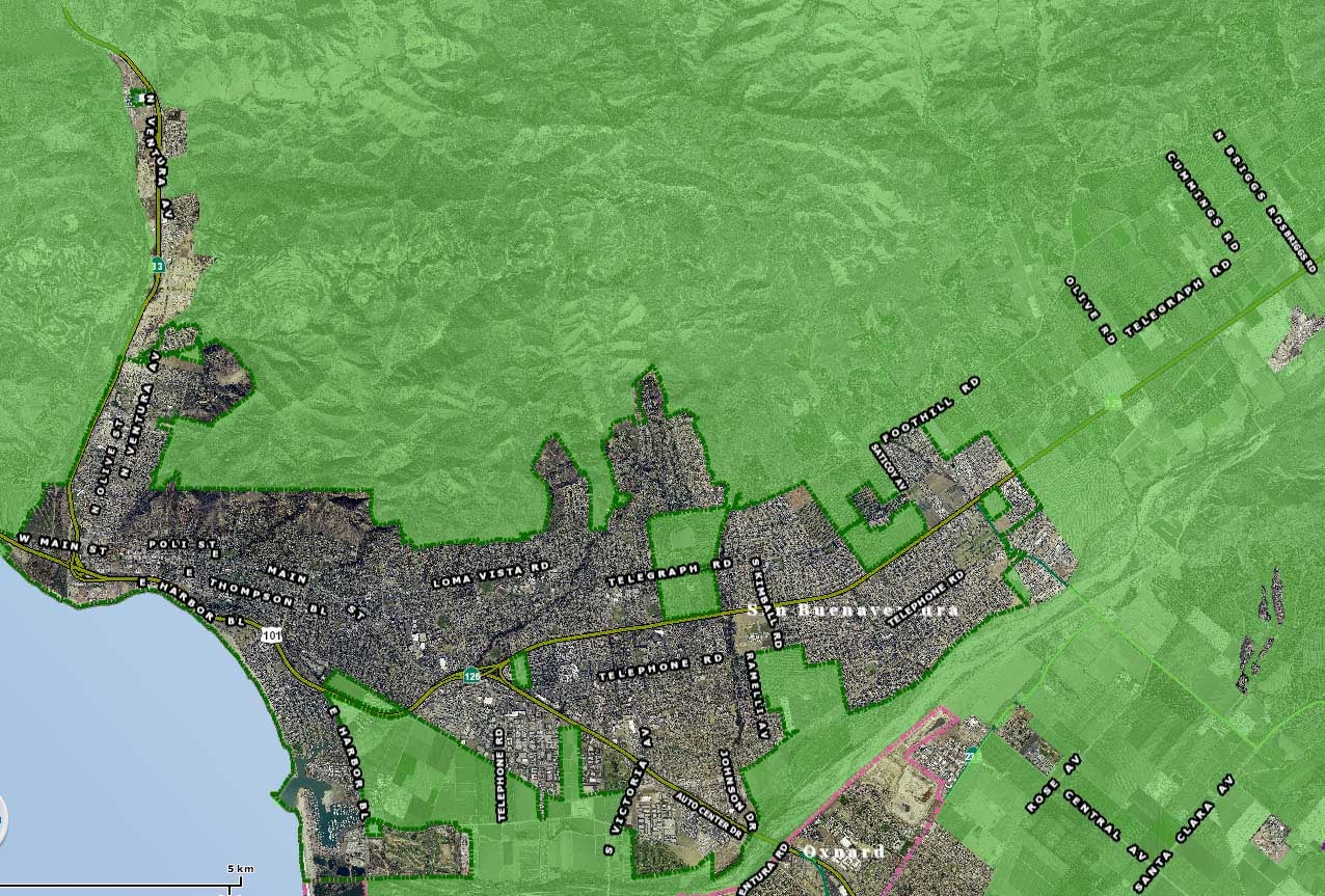
City of Ventura SOAR Boundary Map
The urban restriction boundary established by City of Ventura voters. The subject property falls within this boundary. City SOAR is a separate voter-adopted measure from County SOAR.
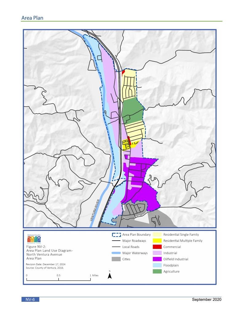
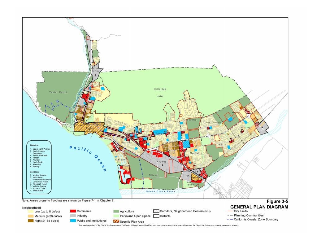
City of San Buenaventura — Official PRA Response Maps
The following two maps were produced by the City of San Buenaventura in response to a Public Records Act request. Both documents confirm the Ventura Ranch site is designated Agricultural and falls within the City SOAR protected boundary.
The SOAR Baseline Map
The General Plan Land Use Map SOAR Attached To at Adoption
When SOAR was adopted by voters in November 1998, it attached to the existing General Plan land use map — locking in the land use designations in effect at that time. County Planning Department staff confirmed in writing, in response to a Public Records Act request, that the General Plan Land Use Map adopted September 16, 1997 (South Half) is the governing map SOAR attached to at adoption.

General Plan Land Use Map — South Half (Sept. 16, 1997)
The governing map at SOAR adoption. County Planning staff confirmed this is the map SOAR attached to when voters enacted it in 1998. The parcels at 4884 N. Ventura Ave. and the area behind Bounds Road are outside the ECU dashed boundary — in agricultural designation. The materials reviewed to date do not identify an adopted authority placing them inside the ECU boundary.
What This Map Shows
On the map SOAR locked in, the land at 4884 N. Ventura Avenue is outside the Existing Community Urban boundary — in agricultural designation. The materials reviewed to date have not identified the adopted public act reconciling that designation with the ECU-Agricultural / Existing Community framework relied on for the Ventura Ranch approval. A change of that kind would require an adopted public act — a resolution, a boundary action, or a voter-approved measure — that can be identified, dated, and traced to an authorizing body.
SOURCE DOCUMENTS
What This Page Does Not Claim
This page does not contend that Ventura Ranch Partners, LLC engaged in wrongdoing, nor does it allege misconduct by County staff, County Counsel, elected officials, or other project participants.
The purpose of this page is to explain the SOAR framework and identify the public-record materials relevant to understanding the Ventura Ranch approval pathway.
SOAR is not a technicality. It is a voter mandate — passed in 1998, continued through 2050 in 2016. The question is what adopted acts moved this land from the Agriculture/Open Space framework voters protected to the approval pathway the County relied on. That chain must be in the public record.
